Maps That Still Work When the Internet Doesn’t
A useful outage map shows more than the road home. It shows the ground you actually depend on.
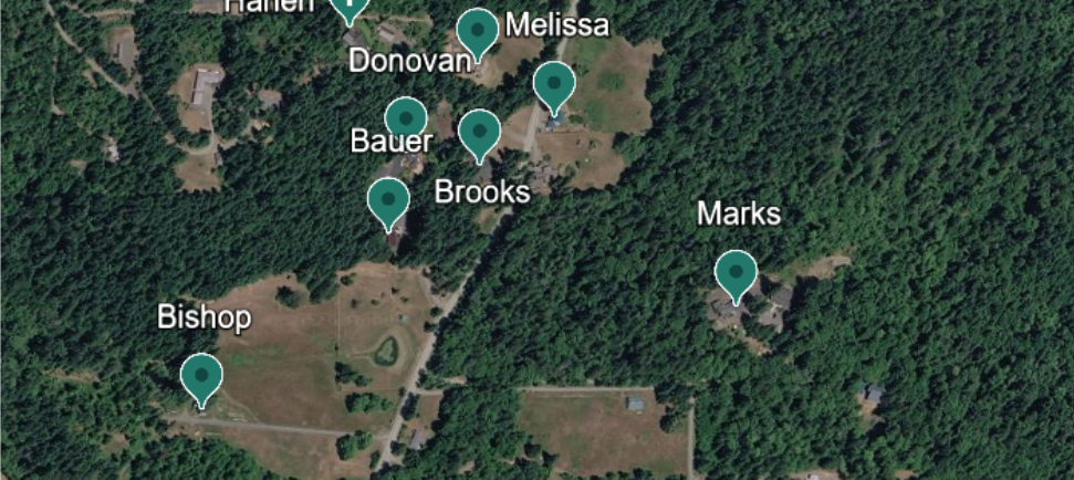
In The Ridge Plan, the power goes out on a winter morning. Soon the phones and internet are down, too. When the neighbors gather in Tom Donovan’s headquarters, he brings up a satellite image of their neighborhood on the television. He had saved it from Google Earth, along with several other images, to a flash drive.
The connection is gone, but the picture is still there.
Later, Helen brings out Walter’s laminated topographic maps. They show the surrounding area at a different scale, with notes about water sources, alternate routes, and places where the radios struggle to reach.
Those maps serve different purposes. Tom’s satellite images help people recognize buildings, roads, tree cover, and the layout they see around them. Walter’s maps help them understand the larger terrain. Both were gathered before anyone needed them.
Most of us have a map in our pocket. We ask our phones for directions and trust the blue dot to keep moving. That works beautifully until the information we need has not been saved, the network is unavailable, or the phone is out of power. A long outage is a bad time to discover that the map you thought you had was only available online.
Start with the area you actually use
You do not need to download an entire state. Start with your home and the places you might realistically need to reach or hear about: nearby households, the roads into and out of your neighborhood, a clinic, a pharmacy, a likely supply point, and a possible place to meet family. Then widen the view enough to see how those places connect.
I think of it in three layers:
- The immediate area. Your property, neighboring roads, intersections, and access points. This is where small details matter.
- The community. The town, rural road network, bridges, and alternative ways around a blocked route.
- The wider region. The routes relatives might use to reach you, terrain that limits travel, and the places you might need to go if staying home becomes impractical.
Tom calls the surrounding ground his area of operations. You do not need his terminology to benefit from the idea. You need to know what lies beyond the end of your driveway and where the roads actually lead.
Use more than one kind of map
A satellite image can reveal the shape of a neighborhood in a way a road map cannot. You can see a large clearing, a bend hidden by trees, or how far a building sits from the street. But a satellite image may be old. It can also make a steep slope look deceptively easy to cross.
A road map answers a different question: Which public roads connect, and where would a driver normally go? A topographic map adds elevation, ridges, valleys, and streams. It helps explain why the shortest line between two places may be a poor route on foot.
That is why Walter’s marked topographic sheets matter in the story. They carry local knowledge on top of the printed geography. The useful part is not just the map. It is what someone familiar with the area noticed and wrote down.
You can build the same kind of reference without making it complicated. Label the maps clearly, date them, and add a simple key for your own notes. Mark a bridge you rely on, a road that floods, a steep hill that becomes difficult in ice, or a meeting point your household has agreed on. Treat any marked water source as a location to assess, never as a promise of safe drinking water.
Save the files before you need them
Tom’s Google Earth images work in the scene because they are ordinary local files on a flash drive. He can open them on a laptop without asking the internet to load a new view. Google Earth Pro has a built-in way to save a map image. For terrain, the USGS provides downloadable topographic maps that you can keep as files or print.
You can also download an area for offline use in Google Maps on a phone. That is convenient for driving, but it has limits:
Google says offline walking and bicycling directions are unavailable, and downloaded areas must be updated before they expire. Think of a phone download as one layer, with saved files and paper copies as backups. Google’s iPhone and iPad instructions explain the current offline-map feature and its limits.
A small folder is enough to begin:
- A close-up image of the neighborhood.
- A road map covering your town and the routes out of it.
- A topographic map of the surrounding terrain.
- A short page explaining your symbols and the date you checked the maps.
Keep one copy on the laptop you intend to use and another on a flash drive. Print the few sheets that would still be useful if that laptop could not be powered. Give the files names a tired person can understand—“Neighborhood,” “Town Roads,” and “Regional Topo” will beat a string of default download names every time.
Do the test that matters
Saving a file is only half the job. One evening, turn off Wi-Fi and mobile data. Open each map using only the device and files you plan to have available in an outage. Zoom in. Find your home. Follow a route to a nearby destination. Ask someone else in your household to find the same destination without your help.
If an image becomes too blurry when enlarged, save a closer view. If a map depends on an account login or a web page loading, replace it with a file you can open locally. If the only copy is on a device you cannot keep charged, print the essentials.
This is also a good time to check the date. Roads change. Construction closes access. A familiar bridge may be missing from an older image. Update the collection when you notice a meaningful change and review it periodically, just as you would check the batteries in a radio.
In The Ridge Plan, the maps do not tell Tom and Claire what will happen next. They give the group a shared picture of where things are, so the neighbors can speak clearly and make better decisions with the information they have.
That is the preparation I would start this week: save a map of the ground around your home, print one useful sheet, and see whether you can still use both with the internet turned off. The best time to find the gaps is while the lights are still on.
The Ridge Plan follows a rural Olympic Peninsula neighborhood through the first thirty days of a grid failure. In this series, I take practical details from the story and look more closely at how—and why—they matter.
Preparedness is only the beginning. The Ridge Plan explores what happens when stored supplies are no longer enough—and ordinary neighbors must turn preparation into decisions, trust, and survival.


